
Few of us today haven’t seen the world beneath us from an aircraft or high building, and aerial views are familiar if not everyday. Just a century ago, the world was very different, and the vast majority of paintings were made from ground level. If the local topography allowed, an artist might climb a hill with their easel or pochard box to sketch what the world looked like from that height. This weekend I look at paintings of aerial views, mostly intended to make the viewer gasp with astonishment at what you could see if you could fly like a god.

In about 1470 Hans Memling created a unique view of the Passion in his Scenes from the Passion of Christ. Not only does this feature a total of twenty-three scenes, from the triumphal entry into Jerusalem to the Resurrection, but these are set in a fictional aerial view of Jerusalem.
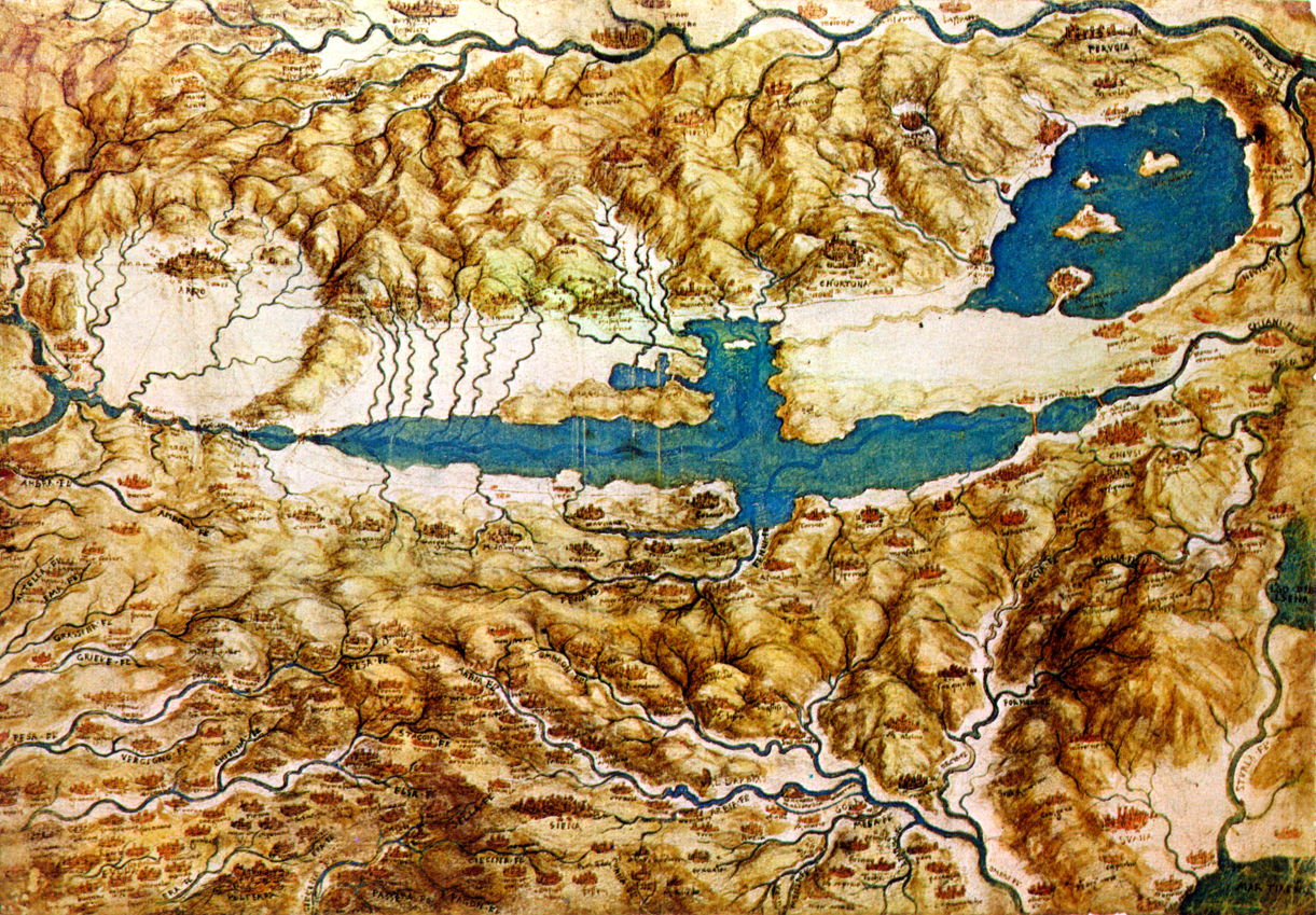
Thirty years later, when he was engaged in advising Cesare Borgia on military engineering and planning, Leonardo da Vinci created one of the first aerial topographic views, in his Topographic View of the Countryside around the Plain of Arezzo and the Val di Chiana from about 1502. This provides an overview with carefully painted miniatures signifying its towns and cities, a tradition that extends to modern mapmaking.
Meanwhile in northern Europe, Albrecht Altdorfer was devising the World View.

Altdorfer’s The Victory of Charlemagne over the Avars near Regensburg (1518), is a landscape secondary to being a visual celebration of this major military victory. Apart from its glaring anachronism of showing cannons in a battle which took place long before their appearance in Europe after 1300, it arrays troops for geometric effect, and for the intense rhythmicity of their arms. Altdorfer was one of the first artists to use a high viewpoint to create a World View, which later evolved into the panorama.

At the same time, Joachim Patinir realised the power of the World View in his Crossing the River Styx (1520-4). The spectator is elevated above the surface and looks on and down over a richly detailed landscape that stretches to the far horizon. Although he has painted a crisp and clear horizon to the sea, he uses marked aerial perspective for the land on the left, making it recede into distant haze, to give the impression of great depth of view.

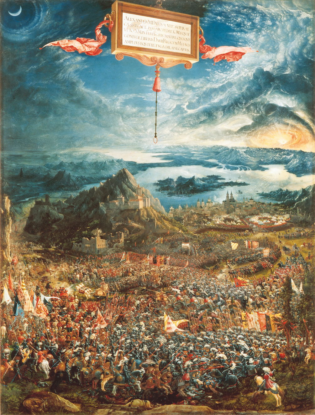
Altdorfer soon came to adapt the World View for a purely military scene, in his Battle of Issus (1529). Keeping his panel in portrait orientation allowed him to show the deep recession in both land and sky. Not only does he paint the soldiers in intricate detail (military precision, perhaps), but also the distant town, and he avoids aerial perspective, which would have left the horizon indistinct.

Of the two views that he painted of his adopted home town Toledo, El Greco (Doménikos Theotokópoulos) made one to combine a topographic view with an inset map of the city. View and Plan of Toledo (1610-14) is unusual for providing such help in relating the map to the ground which it depicts, and may be the first painting to include a map in this way.
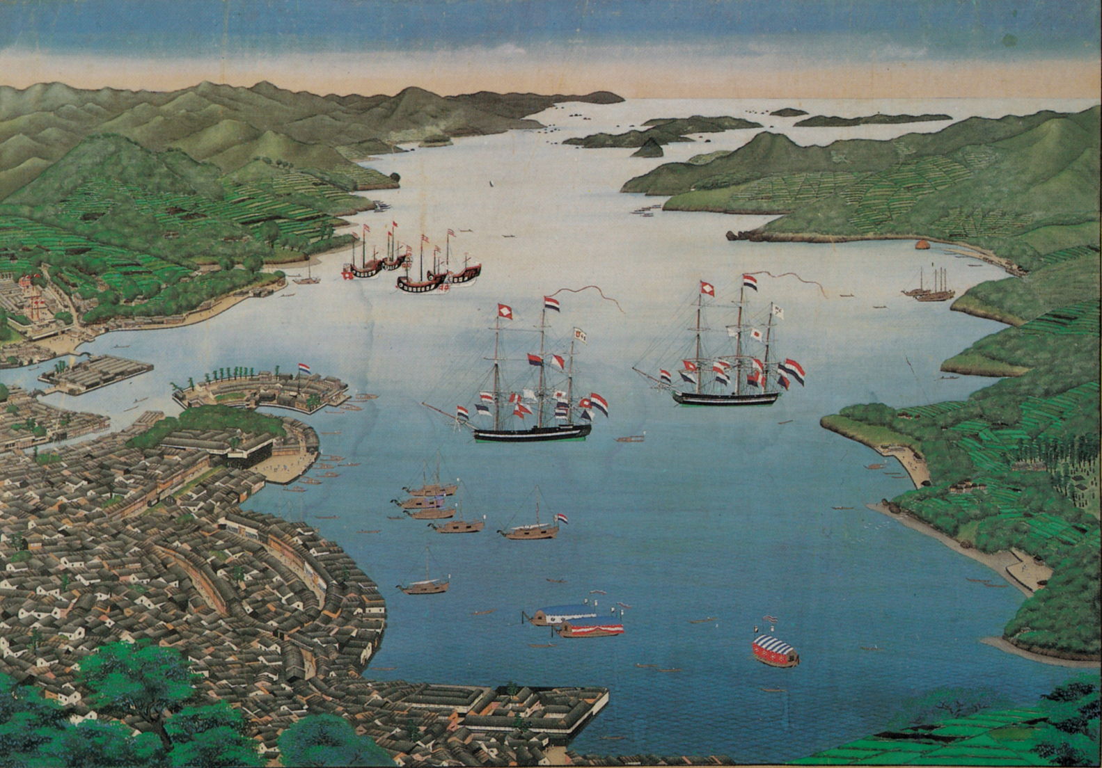
By the end of the Renaissance, the World View seems to have fallen from favour among landscape artists. One unusually late example comes from the Japanese painter Kawahara Keiga (川原慶賀) working in the Edo period. He was painting in the city forming the link between Japan and the outside world, employing Western style and techniques, when he painted this World View of Nagasaki in 1820.

The successor to the aerial World View came in Théodore Rousseau’s Panoramic View of the Ile-de-France, which places the viewer at the level of the rooftops, so as to look over the buildings in the foreground.
By the nineteenth century a few select pioneers were able to get their feet off the ground and experience aerial views through their own eyes.

Gustave Doré’s Between Sky and Earth (1862) is something of a mystery. The viewer is high above the fields outside Doré’s native Strasbourg, where several small groups are flying kites. The kite shown at the upper left has just been penetrated by a flying bird. Another unseen kite, off the top of the canvas, has a traditional tail, at the end of which a very anxious frog is tied to it by a hindleg. However, a stork appears to have designs on seizing the opportunity to eat the frog, and is approaching from behind, its bill wide open and ready for the meal.

Although John Brett’s meticulously detailed view of Florence from Bellosguardo (1863) was painted with his feet firmly on land, it gives the impression of a truly aerial view. Brett painted it from a vantage point at Bellosguardo, a hill to the south-west of Florence, most probably with the aid of a telescope.
Tomorrow I’ll move on to aerial views of the late nineteenth century, and the advent of flight.
