
Painters often paint works which show other paintings, sometimes in tribute to their favourite artists, occasionally even as self-promotion. But it’s more unusual to see a map, chart or similar in a painting. This weekend I’m going to show a selection of paintings which feature these navigational aids, and speculate a little as to why they’re there.

Many maps have been works of art in their own right: this Map of Hell is Botticelli’s intricate three-dimensional map of Dante’s Inferno, which he made in 1480-90 using glue distemper with silverpoint and ink. It remains one of the best depictions of Dante’s elaborate hierarchical taxonomy of sin.

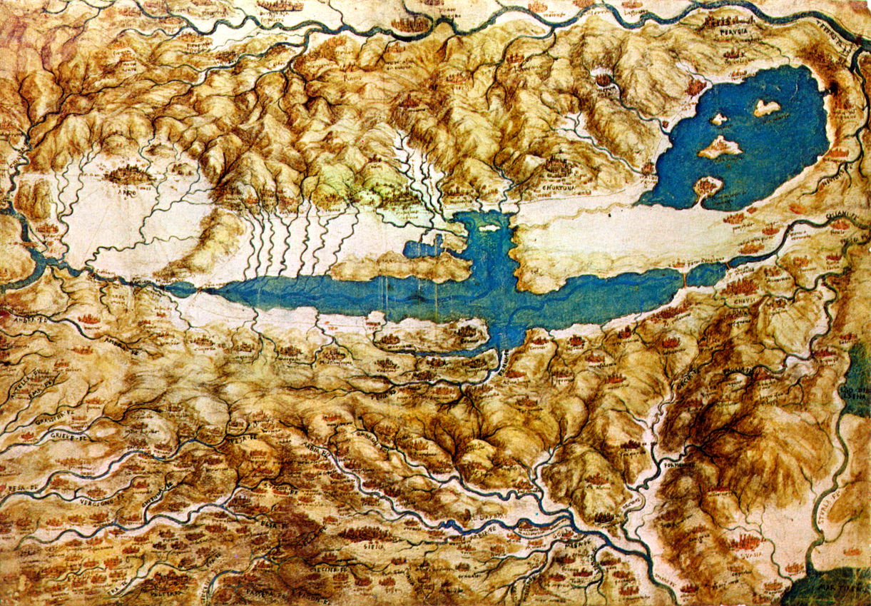
The most famous artistic mapmaker was the polymath Leonardo da Vinci. His finely detailed Plan of Imola from 1502 (above) was made in his advisory role to a succession of the great courts of Italy. It’s the first map to adopt this imaginary bird’s eye view, and dates from when Leonardo was military engineer to Cesare Borgia. Below is Leonardo’s Topographic View of the Countryside around the Plain of Arezzo and the Val di Chiana from the same year. This provides an overview of the area, with carefully painted miniatures signifying its towns and cities, another tradition which extends to modern mapmaking.
Although the earliest surviving globe was made as recently as the end of the fifteenth century, there are much earlier records of them going back to classical times in Greece.

The appearance of both a globe and its complement, the celestial sphere, in Raphael’s fresco of The School of Athens, painted around 1509-10, is therefore unusual but by no means as revolutionary as it might seem. At the right is the figure of Euclid, who is bent over and holding a pair of compasses in his right hand. Behind him are Ptolemy, holding a globe and facing away, and Zoroaster, with a celestial sphere in his right hand.

Another artist who aspired to produce aerial maps was probably Joachim Patinir, if this painting of the The Battle of Pavia is correctly attributed. The slight snag is that Patinir is recorded as having died on 5 October 1524, and this battle didn’t take place until the morning of 24 February the following year. There are significant differences between this painting and one by Ruprecht Heller from 1529, which also attempts to place the armies and events in their topographic context.

Of the two views that he painted of his adopted home town Toledo, El Greco (Doménikos Theotokópoulos) made one to display both a topographic view and an inset map of the city. View and Plan of Toledo (1610-14) is unusual for providing such help in relating the map to the ground which it depicts, and may be the first painting to include a map in this way.
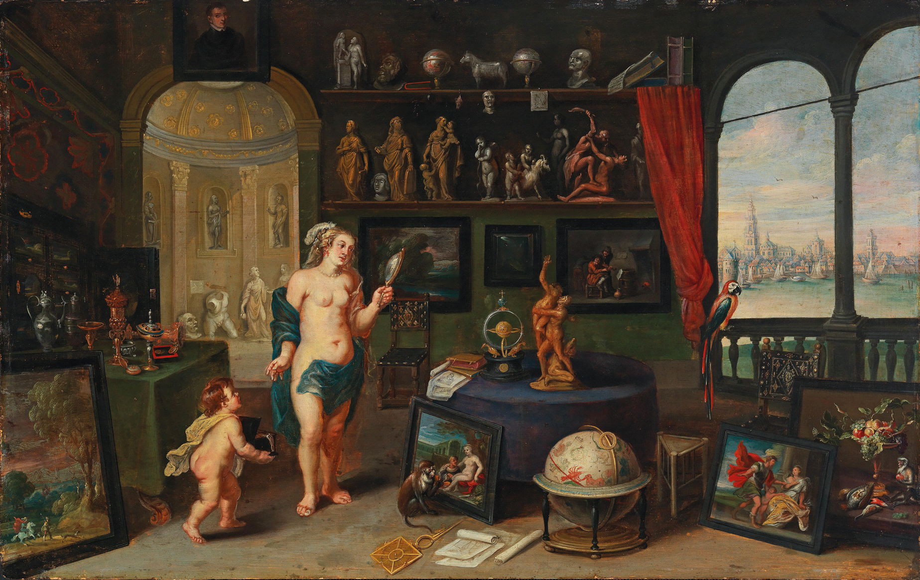
With the rising popularity of paintings of the five senses, globes and maps became established as two of many objects associated with vision.

Jan Brueghel the Elder and Peter Paul Rubens collaborated on their magnificent series of five allegories, including Sight (1617). Among the cornucopia of visual and optical artefacts shown here are a globe and an orrery, a device to show the orbits of the planets.
Frans Wouters provides a brief resumé of Brueghel’s painting in his Allegory of Sight (1635–59). What appears to be a globe in the foreground is actually a celestial sphere marked with symbols of the constellations, and to the left of it are some paper charts.
A more recognisable globe, showing an outline of Italy and the Mediterranean, appears in Peter Paul Rubens’ The Saints Preserving the World from the Wrath of Christ from 1620.
The Dutch Golden Age saw growth in mapmaking to support the international trade which fuelled the country’s economy. Maps and charts became more commonplace among a population more outward-looking, and with its political turbulence.

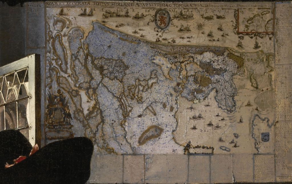
It’s easy to mistake Pieter de Hooch’s A Woman Drinking with Two Men from about 1658 for a Vermeer, and like the latter he decorates the far wall with a contemporary map. The Eighty Years’ War had not long ended, and the Dutch Republic was flourishing. Maps had become popular as domestic wall-hangings.
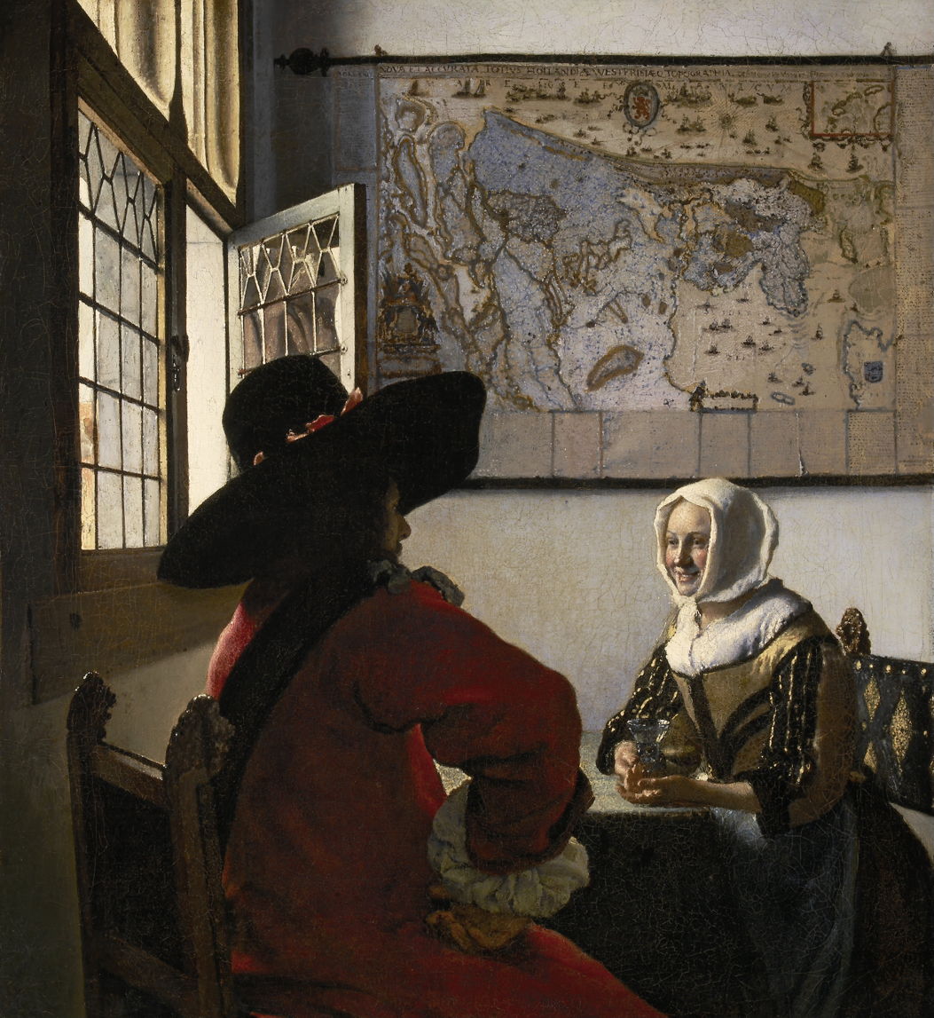
But it was Vermeer who established himself as the master of the map, first in paintings such as Officer and Laughing Girl from about 1657.
The map depicted so meticulously here has been identified as that made by Willem Blaeu and Balthasar Florisz van Berckenrode of Holland and West Friesland. Unfortunately, no other complete copy of that map has survived, but its second edition was published by Blaeu in 1621, and that is believed to be on display here, as shown in the detail below.


Vermeer’s A Young Woman with a Water Pitcher from slightly later shows a different map, although this still appears to show Holland.

The best-known of Vermeer’s maps is that in The Art of Painting from about 1666-68, which appears different again. This turns out to be a map of the Seventeen Provinces of the Netherlands published by Claes Jansz. Visscher. As shown in the detail below, its margins are decorated with panoramic views of the major towns, ornamentation which confirms its use as domestic decoration.

There has been speculation as to whether Vermeer’s maps have any deeper significance or meaning. Could the artist have been expressing his alliance with a political faction of the time, perhaps? I think the most likely explanation is that they were popular wall decorations, and that painting their fine detail strengthened the reality of his images.

In the case of two of his late paintings, their meaning is more direct. The Astronomer, painted by Vermeer in about 1668, shows the figure studying his celestial sphere, which is again marked with the symbols of the constellations.

In The Geographer, from the following year, the figure holds a pair of dividers over an unidentifiable chart, with a fine globe tucked away behind and above him.
