
Whatever their pretensions as works of art, the earliest landscape paintings – and very many since – have fundamentally been visual records of the world. Even since the widespread use of photography, displaying a painting of your hotel, farm, estate, garden, and its surrounds has an attraction for many people.
There are two particular facets of the visual record which I consider here. The earlier, and perhaps more ‘primitive’, is only very loosely tied to topography and location, and is more of an inventory of the objects seen in a locale. As painters became more concerned with the form and structure of locations, those objects became more precisely placed within the view, forming a map.
These ancient varieties of landscape painting relate to the craft of cartography, and to illustration, both in turn linking to print-making. However I will try to confine this account to painting.
Visual inventory
The very earliest landscape paintings, such as some of the remarkable frescoes at Thera, Greece, which date from before 1627 BC, have very loose spatial organisation.
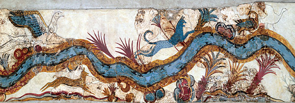
In this view of the Akrotiri River, birds, beasts and plants found along its course are placed decoratively rather than topographically, forming an inventory of what you could have expected to find there. The river itself appears in plan, as if seen from vertically overhead, which is quite a sophisticated projection for the time. The objects themselves are portrayed from the side, almost as symbols might appear on a modern map. However these birds, beasts and plants are not mere symbols: most are depicted with considerable detail, and using two or more different colours to give them form.
More than three thousand years before the Renaissance imposed the expectation that such views would be portrayed in perspective, this is a beautiful work of art. Furthermore it would take artists several centuries after the Renaissance before they would dare to break the convention of perspective, and return to using multiple projections within a single painting, in Cubism.
My next example comes from another remarkable pre-Renaissance painting, Ambrogio Lorenzetti’s (1285–1348) Effects of Good Government (1338-9), in Siena, Italy. Here I show just the section of countryside, at the right of the whole fresco, outside the city wall. Shown using an elevated view is an idealised pastoral landscape, populated by productive workers. The plain in the foreground is a hive of activity, with laden animals crossing a bridge, and making their way up the steep road to the city gate. Rolling hills in the distance contain a patchwork of small fields growing grapes or other fruit, and there are prosperous houses, farms, and estates scattered liberally.
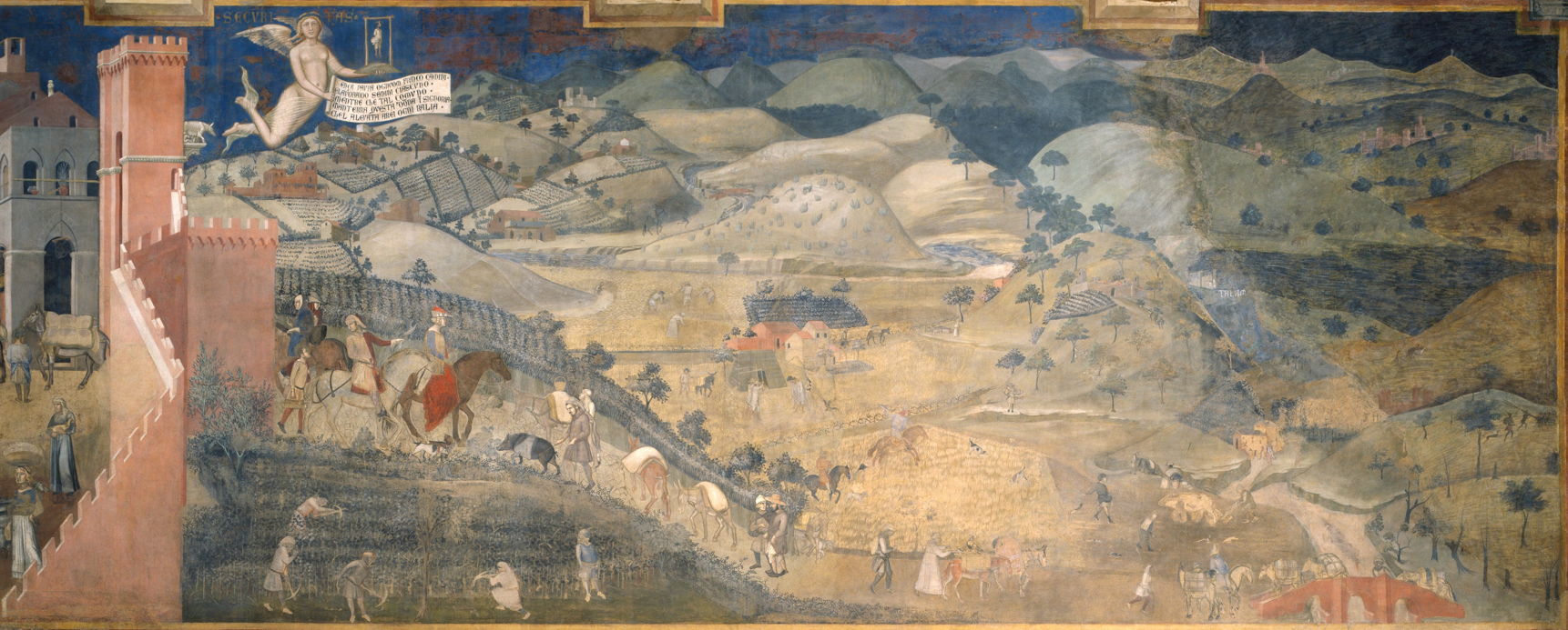
Although here the directory sprawls out over the landscape, the trees, houses, and people are clearly tokens or symbols, and the painting a listing of the benefits expected to result from good government. Its approach to perspective and projection is more uniform, but clearly pre-Renaissance still.
Lucas Cranach the Elder’s (1472-1553) The Garden of Eden (1530) is not only a visual catalogue of the birds and beasts he envisaged were present in the garden, but shows six different scenes of the Biblical story of the Fall of Man in the same composite view.

To the left of centre, in the distance, is the creation of Adam; Eve is then brought out of Adam’s rib in the far right. To the left of that the couple are together, before God talks to them both (centre), then Eve tempts Adam with the apple (mid left). The sequence ends on the far left, with Adam and Eve being cast out from the garden.
Little later than that, Nicholas Vallard or a contributor painted what is believed to be the first map of Australia, then termed the East Coast of Jave la Grande (1547) (here shown in a much later print). Against a labelled outline of the coast, as far as it was known then, is a catalogue of people, their dwellings, beasts, and aquatic creatures that the artist thought might be found there.
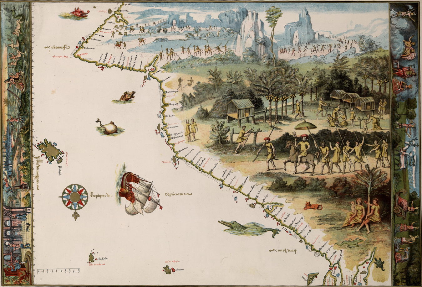
The objects shown are integrated into a view with a consistent projection, and scaled to provide a sense of perspective. However they are clearly out of proportion to the coastline. This visual information is supplemented by panoramas running along the left and right edges of the map.
Leap forward almost four hundred years, and we find André Lhote’s (1885-1962) Vue de Paris ou La Seine au point du jour (1926) seen at Galerie Pluskwa or WikiArt. (This painting remains in copyright, and there is no freely reproducible image available, I am afraid.)
Lhote’s gently Cubist view of Paris at dawn serves as a catalogue of landmarks around the Seine and its barges, only loosely related to their physical location. As it shuns the earlier radical Cubism, it does not confound by presenting many different views of the objects within it, but is still a step back from the rigid perspective which had ruled since the Renaissance.
Topographic views
The site at Thera contains an even more remarkable painting known as the Flotilla Fresco. Although these frescoes have been dated to before the catastrophic volcanic explosion in about 1627 BC, which destroyed the local (and most of the Minoan) civilisation, it is not known whether the frescoes are of similar dates.
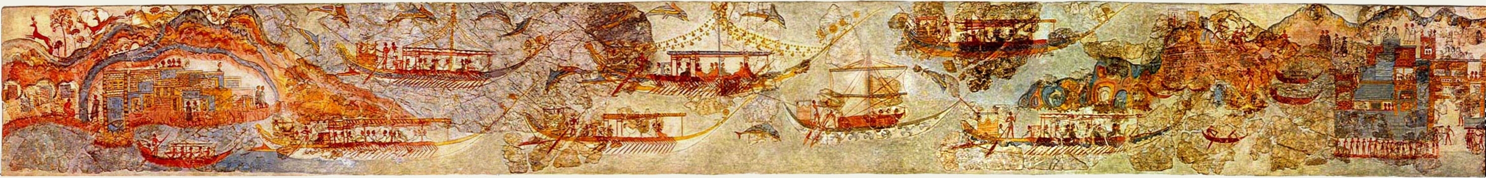
Looking in more detail at this fresco reveals that it depicts local topography fairly accurately, showing a flotilla of boats setting off from one town, and crossing to another.

There appears to be considerable accuracy in the depiction of buildings and people in the towns, rather than the more symbolic objects shown in the Akrotiri River (above).

The later making of maps was an activity which frequently overlapped with artistic rendering of landscapes. Early ‘mappa mundi’ depictions of the medieval world usually lacked painterly embellishment, but more local maps were more commonly based on painted aerial views.
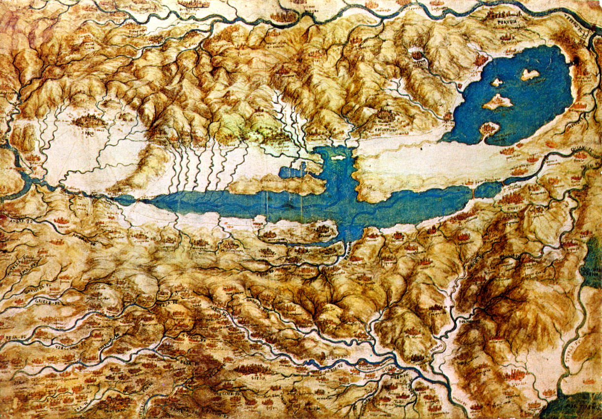
Leonardo da Vinci’s (1452-1519) service to Cesare Borgia from 1502 resulted from the detailed map that da Vinci made of Imola, and he was then employed as Borgia’s chief military engineer and architect, not his court painter. Da Vinci produced his Topographic View of the Countryside around the Plain of Arezzo and the Val di Chiana (c 1502) to provide an overview of the area, but took care to paint miniatures of each of the towns and cities, as if viewed from high above the earth.
I have already remarked on the problem over dates in attributing the very topographic The Battle of Pavia (c 1530) to Joachim Patinir, who died in 1524, a year before the battle took place.

Largely forgotten now, this battle between the Spanish-Imperial and French armies outside the city walls of Pavia, Italy, resulted in a resounding defeat of the French. There are significant differences between this painting and one by Ruprecht Heller (1529), which also attempts to place the armies and events in their topographic context.
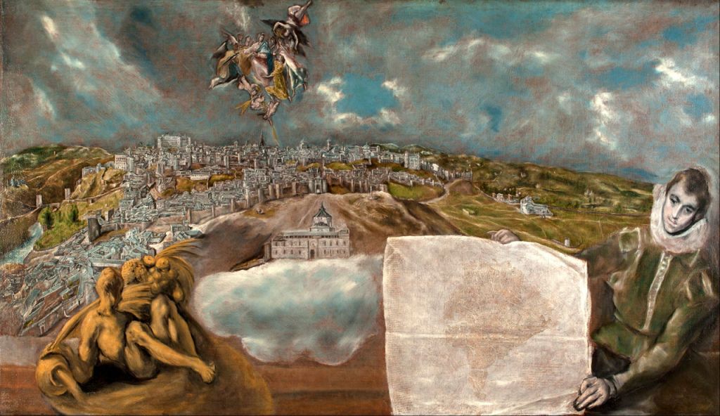
Of the two views that he painted of his adopted home town Toledo, El Greco (Doménikos Theotokópoulos) (1541-1614) made one to display both a topographic view and an inset map of the city. View and Plan of Toledo (1610-4) is by no means the only painting to show a paper map, but is unusual for providing such help in relating the map to the ground which it depicts.

During the centuries of exploration, discovery and subsequent empire-building, the work of professional cartographers was often supplemented by more painterly views. Joan Vinckeboons (1617–70), who is known for his map-making rather than as an artist, made many landscape views of the new lands using pen and watercolour, such as this of Havana, Cuba (c 1639). These were later published in collections, and converted into more conventional plans and charts.

In both World Wars, agents working behind enemy lines posed as painters in order to create landscape drawings and paintings, which were then used to generate maps of the disposition of heavy guns and other military features. Many cartographers have also turned maps into aerial views and published them via engravings and other prints. Topographic views are also standard in the repertoire of illustrators, and remain very popular in books for both adults and children, covering history, geography, and of course travel guides.
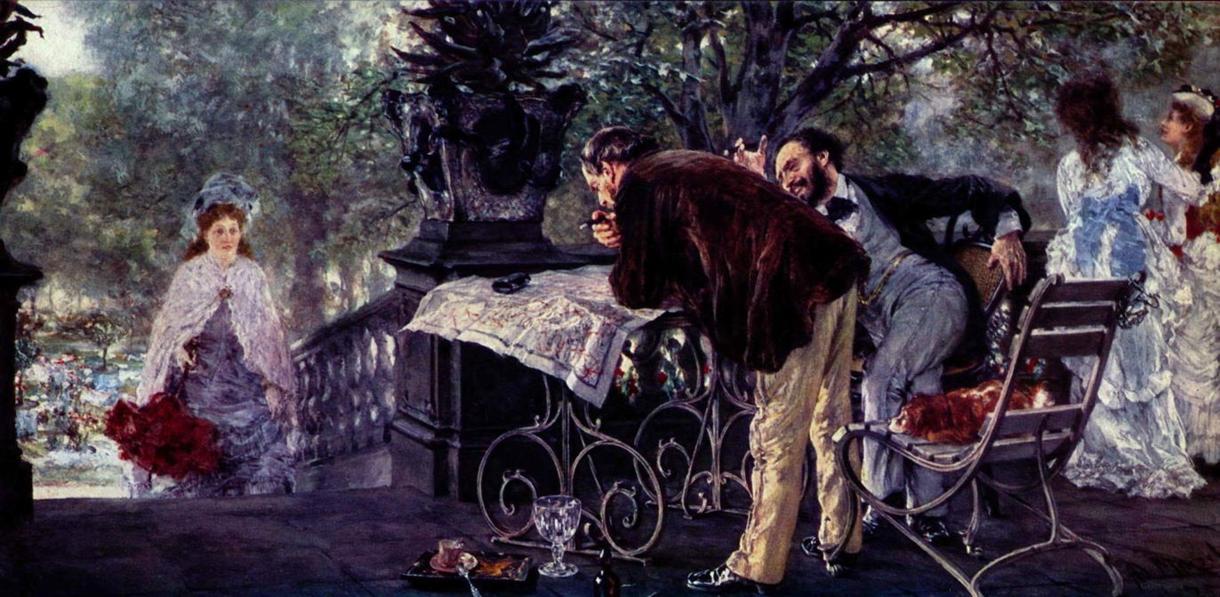
I end this short survey with an example of a topographic map in an Impressionist painting: Adolph Menzel’s (1815–1905) wonderful Travel Plans (1875). Here the two men are discussing where they should go on holiday, in the light of the possibilities revealed by their map.
Summary
Early landscapes, including some of the earliest in existence, provided a visual inventory of what was in the landscape which was not well related to their actual location. Although these died out with the Renaissance and its emphasis on perspective and projection, they reappeared with Cubism in the twentieth century.
Other landscapes, from the earliest recorded, have functioned as topographic records, and there has been mutually beneficial exchange with the craft and science of map-making. Currently they are most commonly encountered in the work of illustrators, as published in many books.
