
Most days, if the weather isn’t too horrid, we walk about thirty minutes from our backdoor up to an obelisk on the Down to the west. From there, on a clear day, we can see the English Channel coast from Durlston Head in Dorset to Selsey Bill in Sussex, a stretch of over fifty miles. Cross the sea to the south of here, and beyond the horizon you’ll reach the Cherbourg Peninsula in France, from where we get most of our thunderstorms.
This weekend I celebrate the sea known variously as the English Channel or La Manche, which stretches from Land’s End in Cornwall and the island of Ushant or Ouessant off the western tip of Brittany, up to its shortest crossing between Dover and Calais. It’s a sea far less exotic than most others, often inclement even in summer, and painted more than most.
Today, we start from Land’s End and head east along the south coast of England towards Dover; tomorrow we cross to Calais and travel west along the north coast of France to end at Ushant.
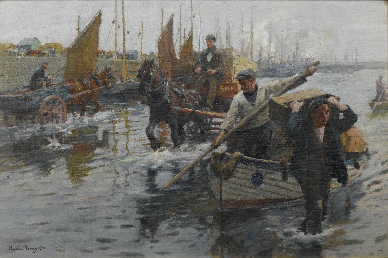
Harold Harvey’s Unloading the Boats, Newlyn Harbour (1906) shows the intense manual handling required to unload the catch from small fishing boats in this harbour not far from Land’s End. Harvey was born in Cornwall and trained at the nearby Penzance School of Arts under Norman Garstin, later becoming a leading member of the Newlyn School.

Clarkson Stanfield’s dramatic painting of Mount St Michael, Cornwall from 1830 is one of his finest. It shows what is now more commonly known as Saint Michael’s Mount, a small rocky island off the south coast of Cornwall, and the defining feature of Mounts Bay. Like its sister on the other side of the Channel, which I’ll show tomorrow, it packs a lot of buildings onto its small surface.
The artist uses several devices which he must have learned earlier in life as a scenery and panorama painter to inspire maximum awe: the heavy clouds open to blue sky just at the right place to cast the sun’s light onto the buildings, his viewpoint is only just above the short, steep sea, and foreground activity consists of small boats attending to a wrecked ship.
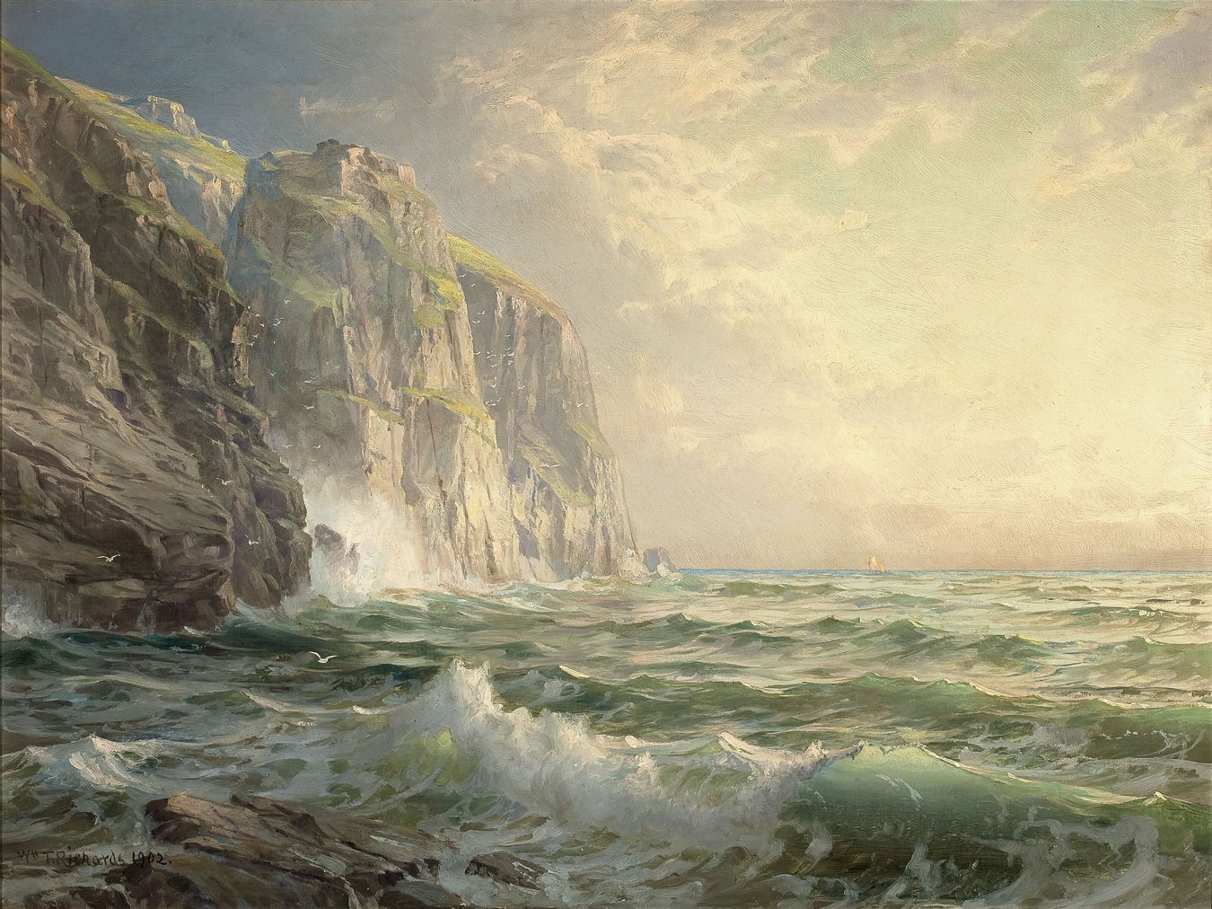
William Trost Richards’ Rocky Cliff with Stormy Sea, Cornwall (1902) follows Clarkson Stanfield’s romantic approach in its depiction of this rugged stretch of the coast.

This painting has been attributed to Anton Melbye’s younger brother Vilhelm, and shows Shipping off the Eddystone Lighthouse. This is one of the most famous lighthouses in the British Isles, being on rocks which are about nine miles south of the entrance to Plymouth Harbour, in Devon.
The first lighthouse built here in 1696-98 was destroyed completely by a storm in 1703, killing its builder, Henry Winstanley, and five others. This painting shows the third lighthouse, also known as Smeaton’s Tower after its designer, which remained in use until erosion to its foundation rocks allowed it to rock in storms. The current lighthouse replaced it in 1882.
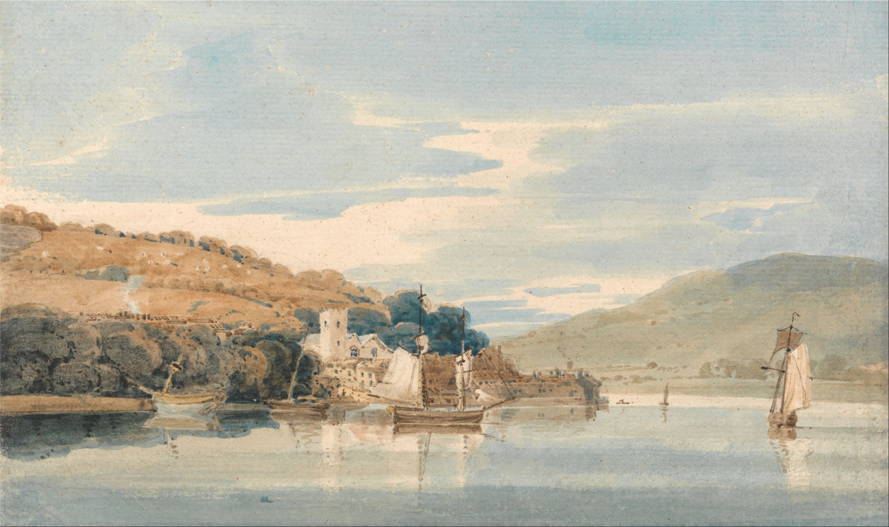
In 1797, Thomas Girtin painted in Devon and Dorset, including this beautifully informal view of Kingswear Seen from Dartmouth, Devon (c 1797). This shows one of the picturesque estuaries typical of this section of the Devon coast.

When you reach the coast of Dorset, the scenery changes dramatically, with chalk flowing from hills down to the water’s edge. John Brett’s Man of War Rocks, Coast of Dorset (1884) shows Pre-Raphaelite landscape characteristics of foreground detail, meticulous geology, and bright colours.
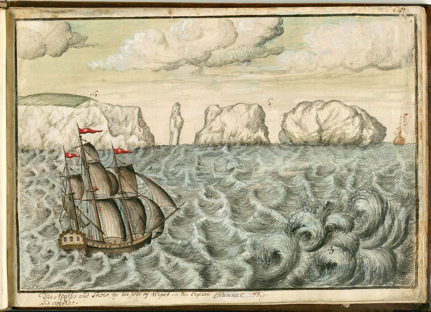
This chalk coastline becomes steadily more spectacular as it reaches the Isle of Wight. The most famous landmark there is the Needles, chalk sea stacks which have been both a welcome and a hazard to mariners over the centuries. These were presumably one of the first sights of Europe when Philipp Georg Friedrich von Reck returned from his pioneering stay in North America. The sea in this page from his sketchbook may appear a little overwrought, but it’s faithful: this channel in the Western Solent is home to one of the more spectacular tidal races of the Channel coasts, and often generates short, steep waves of more than a metre in height.
Tides and their effects are prominent along much of the Channel as it connects the much larger Atlantic Ocean and North Sea, funnelling the movement of very large volumes of water through a relatively narrow channel. In places, these can become quite odd, to the north of the Isle of Wight leading to ‘double high tides’ which enabled the development of the large port of Southampton.
The Needles also forms the backdrop to JMW Turner’s early success of Fishermen at Sea from 1796. This shows small fishing boats working in heavy swell off The Needles, and was his first oil painting to be exhibited at the Royal Academy.
Closer examination of the painting reveals that, even at this early stage in his career, Turner wasn’t painting motifs as they were in nature: from the position of The Needles, this view would look to the south-west from Totland Bay.
Yet he shows the distant promontories of the south-west coast of the Island, as if the view was made round the other side of The Needles in Freshwater Bay looking south-east instead. Another group of chalk sea-stacks was located there, with some common appearances to those at The Needles, and it’s probable that Turner merged them and added the background from the south-west coast.

Richard Burchett’s View Across Sandown Bay, Isle of Wight show the more popular but less scenic south-east coast of the Isle of Wight, where its chalk spine drops away into the Channel.

Much of the coast to the east of the Isle of Wight is flat and has had limited attention from major landscape painters. This is shown well in Paul Nash’s aerial view, The Shore (1923). This is one of the many strongly geometrical paintings and prints which Nash made of the south Kent seafront and coastal defences. Stark straight lines of concrete divide the canvas up into a series of flat planes; even the sea, caught in a moment of calm, forms a plane.

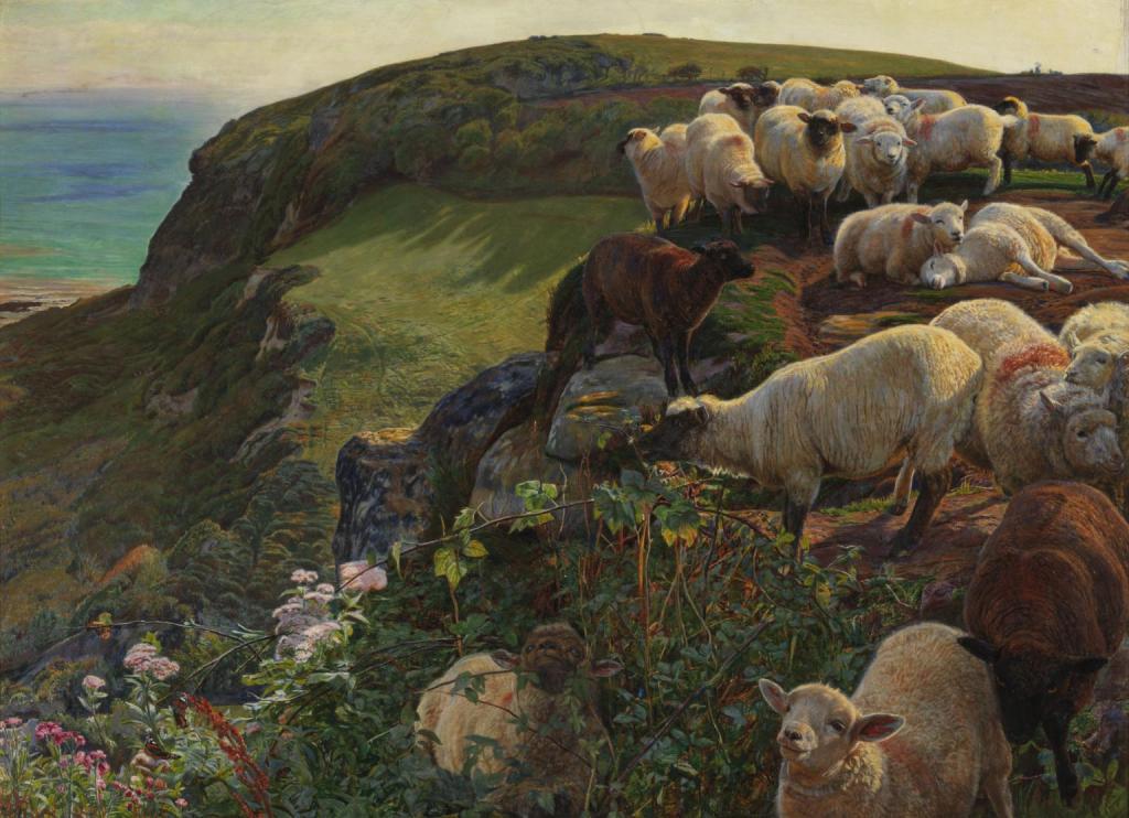
Further to the east, the coast rises again in a succession of cliffs, where William Holman Hunt’s Our English Coasts, 1852, was painted in that year. Although this doesn’t quite depict a real view, Hunt based it on the Lovers’ Seat, overlooking Covehurst Bay, near Hastings. It was near here that the Norman king William ‘the Conqueror’ landed in 1066 to win the crown of England.
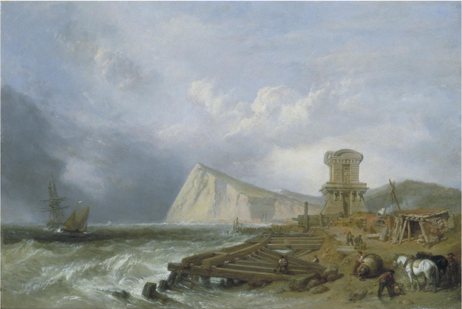
Clarkson Stanfield painted two versions of The Seashore at Dover in about 1849, one which is now in the National Maritime Museum in London, and this slightly smaller version. It’s a windy day, with scattered and blustery showers. The famous white cliffs of Dover rise high in the distance, as the wind blows the tops off the small waves in the foreground. The construction work in the foreground relates to the final section of the London to Dover railway, which made travel from England to France much quicker and more convenient.
Tomorrow we’ll cross over to France.
