
As the rest of the world knows, the British Isles are noted for their weather. We have lots of it, and here ‘it’ includes every type of rainfall known to man and Mancunian.
It is therefore only appropriate that Britain has long been at the top table for weather forecasting. In fact I think we invented that table, and knocked the first one up using driftwood and sailcloth.
The BBC’s online Magazine has recently run an interesting feature on Admiral FitzRoy and the earliest weather forecasts, although it gives little insight into today’s weather industry. For when you have much at stake on the weather – a major outdoor event, for instance – you can pay to get special local forecasts, and even offset any financial risk on the insurance market.
For most of us, though, the only thing at stake is whether we should take a mac and try to dodge the showers, or can stroll out safely in shirtsleeves.
There are four main options for weather forecasts in such a changeable climate:
- use radio, TV, or newspaper forecasts, which are not localised, and are prepared well in advance;
- use an app for iOS which tries to give both medium and very short term forecasts for your location;
- use free online resources to make your own forecast;
- emigrate to somewhere like California or Western Australia.
However attractive the last might be, most of us are stuck with one of the first three, and I will assume that, as you are reading this, you are not prepared to risk all on those forecasts delivered in 30 seconds or so via broadcast media. You want something better, and typically for the next hour or two: what is reasonably called a nowcast.
iOS apps
If an app is going to be useful for nowcasting, it has to be able to go with you, so it will run under iOS on iPhones and iPads. Rather than try to cover every app, I confine my attention and evaluation to:
- Weather, bundled and free,
- Met Office, free with in-app purchase £2.29 to remove ads, from the iTunes Store,
- Dark Sky, £2.99 from the iTunes Store,
- Rainradar UK & Ireland, free with in-app purchase £1.49 to remove ads, from the iTunes Store.
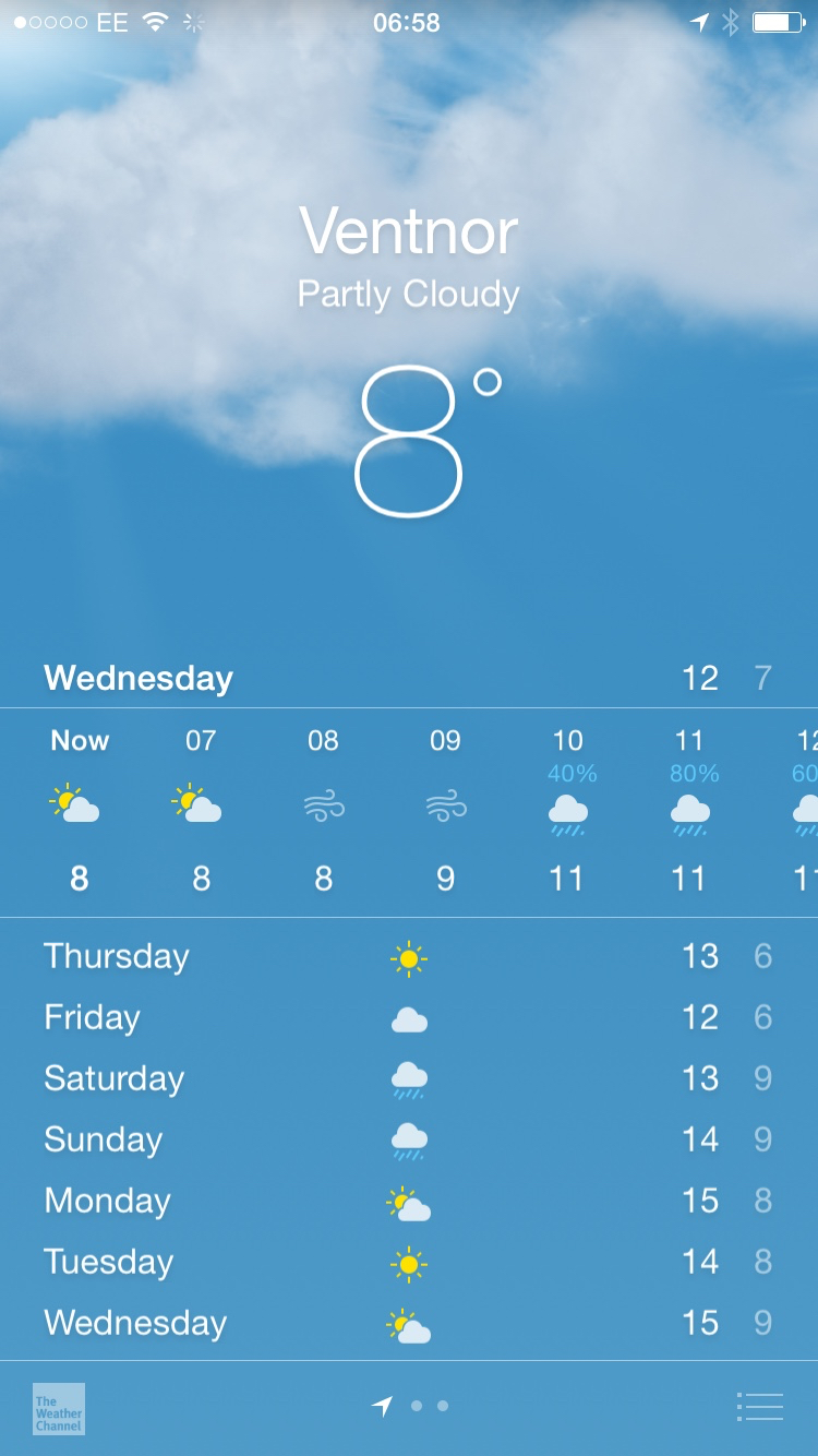
Weather is the standard forecast from the Weather Channel, giving 7 days ahead in outline, and the next 24 hours in detail, hour by hour.

Met Office is the official offering from the UK’s state forecasting service, and has not always been particularly stable in the past. At present it gives both local forecasts and UK-wide rainfall radar maps, which project into the future for the rest of the current day. The next 5 days are given in outline, the coming 2 days hour by hour. Its rainfall radar map offers predicted rainfall hour-by-hour for the next 5 hours, then at less frequent intervals for the rest of the coming 28 hours or so.
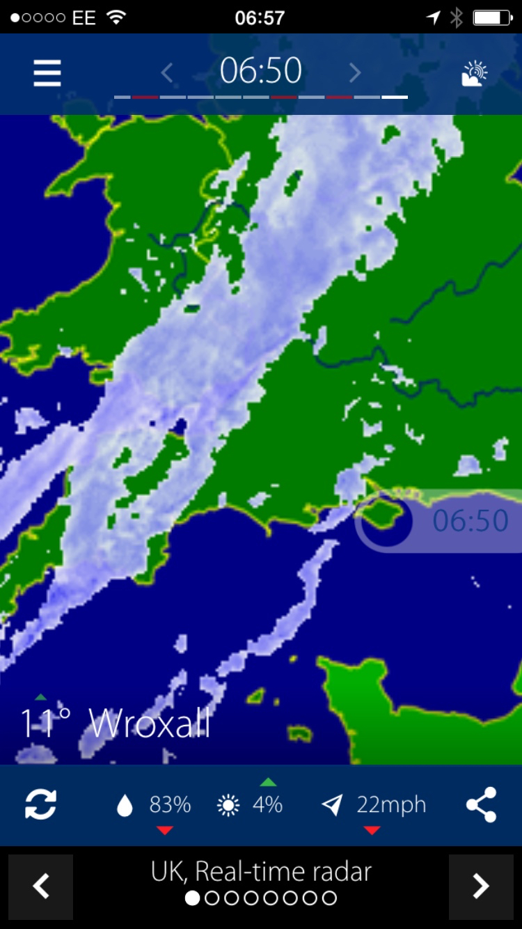
Rainradar comes from the Meteo Company, a private forecasting bureau, and is centred on rainfall radar and satellite imaging. It provides 8 different map views, showing real-time rainfall radar, a radar-based forecast, snow radar, visible (daytime) cloud satellite, infrared satellite, sun and clouds, satellite rain, and lightning strikes on rainfall. It also provides 3-hourly forecasts for the rest of the day, and daily summaries for the following 7 days.

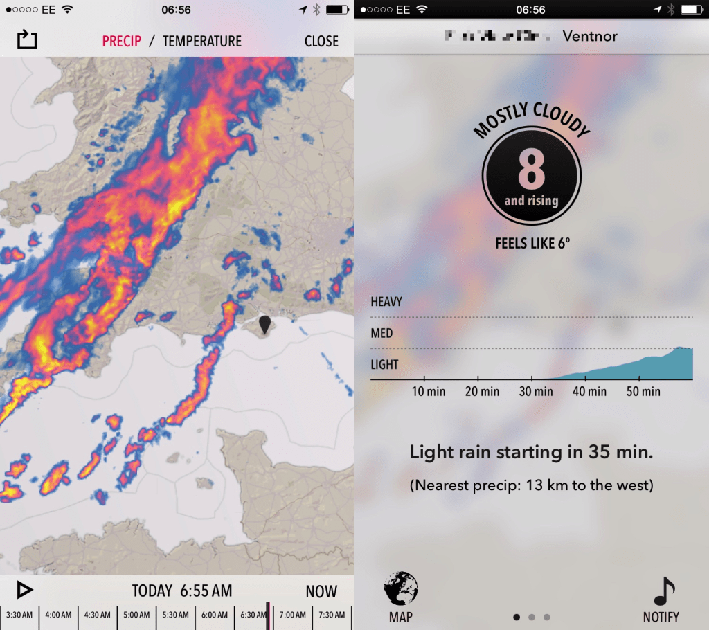
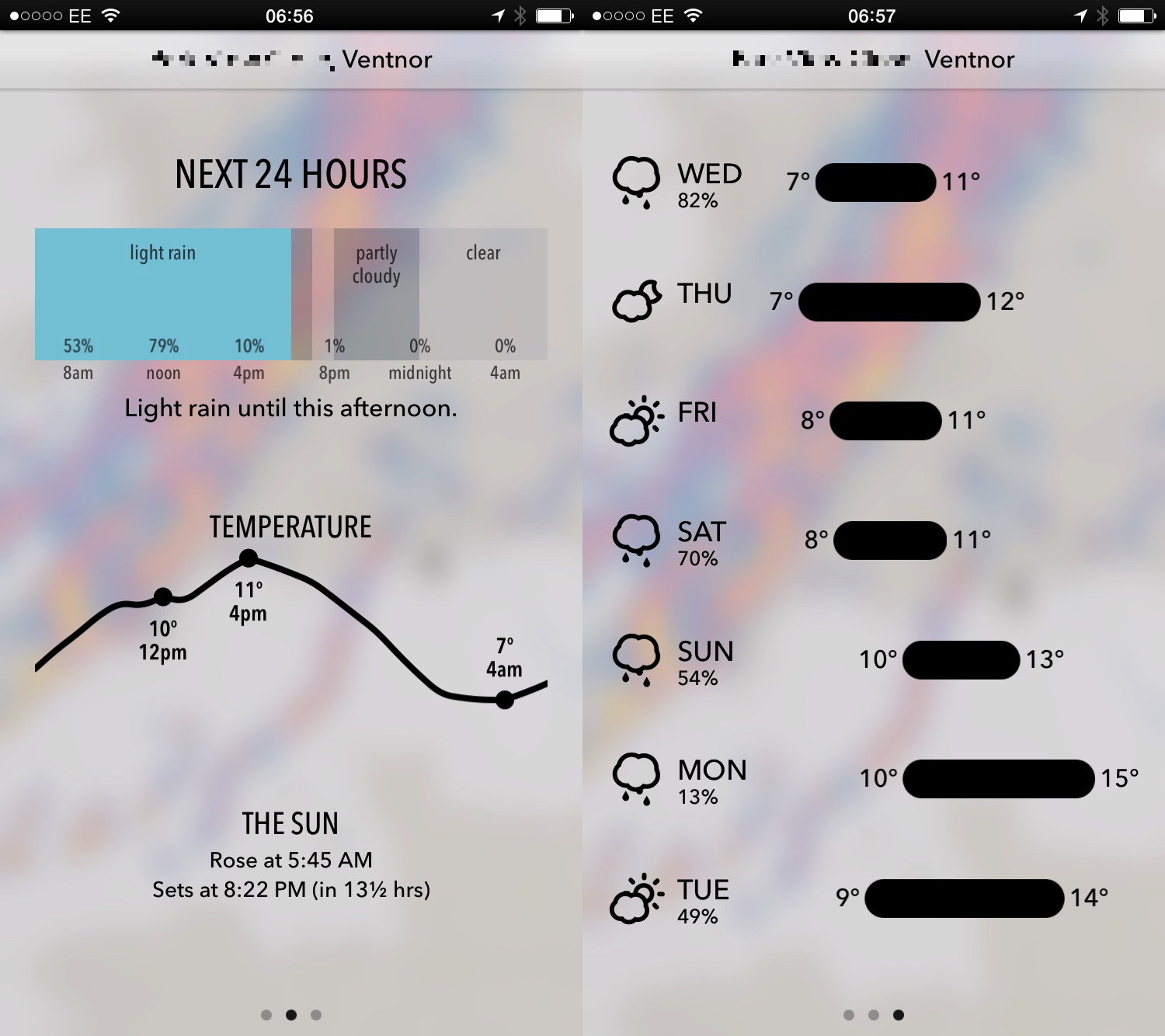
Dark Sky came with Christopher Phin’s (former Editor-in-Chief of Mac Format) strong recommendation that it was ‘spookily accurate’ in forecasting even local rain showers, and emanates from another private forecasting service, The Dark Sky Company. It concentrates on two key variables: rainfall and air temperature. A summary forecast outlines the next 7 days in terms of rainfall and temperature ranges. A second screen gives weather and temperature in detail through the next 24 hours, a third provides more detail for the next hour, and there is a high resolution map showing rainfall or temperature over the last 4 hours, which can play in animation.
Where do they get their data?
Gathering meteorological data is an expensive game, requiring a worldwide network of weather stations, numerous geostationary satellites, huge radar arrays to plot precipitation, and supercomputers to analyse and forecast. Private forecasting bureaux work by purchasing those data from the national meteorological services, and presenting them and their own derived forecasts to paying customers.
So the odd but essential fact is that the underlying rainfall radar data used to power the map displays in the three apps which offer such maps is identical.
The latter two apps do something that the UK Met Office does not, which is to pool the rainfall radar data from the UK and France (and other agencies covering the rest of Europe), so as to produce complete cover; by convention the UK Met Office does not apparently itself display rainfall radar beyond agreed limits.
How do these apps forecast?
None of these apps runs any weather or forecast models on your iPhone or iPad. They simply obtain their data from their parent forecasting service, which also powers their free websites.
Forecasting rainfall (or, strictly, precipitation including rain, snow, hail, etc.) appears to be performed quite simply by taking the current rainfall radar map and projecting it forward linearly. So if there is a belt of heavy rain which has been moving northeast at a steady 20 miles per hour, it is assumed that it will continue in the same direction, intensity, and speed.
In reality, rainfall behaves differently, of course. As a band moves, it may weaken or intensify, split or broaden, and its direction and speed may also change considerably. Although these changes may form part of the more general numerical forecast, I can see no evidence that any of these apps modifies their nowcast in such ‘smart’ ways: they each appear to use simple linear extrapolation to forecast rainfall in the short term.

Temperature and weather are forecast from the numerical forecast models generated by meteorological supercomputers. Those models are very mature, but are most accurate at predicting pressure and windspeed at various heights in the atmosphere. From pressure charts come details of weather systems, thus cloud cover and the temperature of air masses (according to their origins). Forecast cloud cover in turn allows you to predict likely temperatures, according to how much or little sunshine may warm the air during the day.
Air temperature changes over a daily cycle, typically being lowest around dawn, and highest in the early afternoon, as modified by frontal systems, changing cloud cover, and more. It is thus relatively difficult to forecast accurately, and slight changes – such as the arrival of fog (another type of weather which is very hard to predict accurately) can have large and relatively unpredictable effects on temperature.
It is very important to appreciate that, however much it might appear that someone, somewhere is preparing you a personal weather forecast for your local area, all these weather apps do is look up where you are at the moment and get routine predictions for what is expected to happen there.
They do not know anything about local weather effects such as frost hollows, or rain shadows. Maybe at some time in the future weather forecasts will have such fine resolution, but at present they do not, and there is no evidence that these forecasts have any such local ‘wisdom’.
How well do they work?
Much of the time, each of the four apps gives reliable and accurate forecasts. They work best when the weather is most stable and easily forecast, and become significantly less accurate when the weather is more changeable and harder to forecast. Given that they rely on the same underlying data, the differences in forecasts are usually very small.
Weather is actually an excellent free app if you like the simple and crisp forecasts which it provides. If these are not as detailed as you prefer, you should augment it with one of the others.
Met Office provides the most detailed rainfall radar forecast (rather than history), which is therefore inevitably the most likely to be incorrect. However when it does turn out to be accurate, it appears very impressive, and being linked in to the main numerical forecast, will tend to be more accurate than simple linear predictions. My main problem with this app has been its stability in the past: if the Met Office can ensure that it does not crash as often in the future, it is a good choice.
Rainradar is ideal for anyone who has learned how to get the best out of rainfall radar and satellite imagery. Although its forecasts are fairly standard in quality, its high-resolution rainfall animations are the best of all the apps, and alone justify its use.
Dark Sky looks far more precise and reliable that it actually appears to perform. Although it might seem very helpful to be told that there is no rain in the next hour, or that moderate rain will start in 14 minutes, in reality it claims false precision.
Sometimes it does appear ‘spookily accurate’, but sometimes it is wildly wrong, and keeps changing its mind. However my biggest problem is with its rainfall radar maps, which appear to have undergone smoothing from the original data supplied. As a result they often differ in detail from those of the UK Met Office and Rainradar, although appearing more sophisticated.
All these apps are prone to being misled by errors in the underlying data. Rainfall radar is not perfect, and at times can indicate spurious rain, or can miss quite significant downpours. One common phenomenon near the Isle of Wight is spurious linear reflection from what I presume are navigational radar reflectors on the Nab Tower, an offshore structure to the east of the Island. These commonly occur during fine, stable weather, particularly at night time.
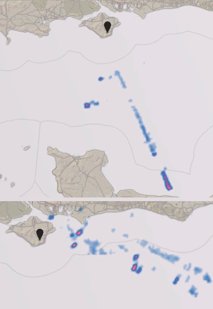
None of these apps is smart enough to be able to tell such spurious clutter on the rainfall radar from real rain, and will therefore warn you of nearby rain when there is not a cloud in the sky.
Clouds and rainfall also alter when they come into contact with substantial hills and mountains, and commonly intensify towards the windward (weather) side of the crest as they undergo uplift. This can cause clouds which were not producing rain to suddenly result in a downpour when they reach a ridge of hills, something that rainfall radar and linear forecasting cannot predict at all.
During periods of fine weather, when the sky remains clear of cloud at night, actual minimum temperatures are often more than 5 deg C colder than forecast, and shade maximum temperatures during the daytime can be more than 5 deg C warmer than forecast. At times like these, Dark Sky can appear of very limited use, as it is also obvious that there will either be no rainfall at all, or any showers will be highly unpredictable.

Another major shortcoming of these apps – with the exception of Met Office – is their focus on rainfall and temperature. This is most apparent in Dark Sky, which gives no information at all about wind, fog, and other important and sometimes life-endangering weather. Not only can these have major impact on us and our activities, but they also modify our perception of air temperature: the ‘wind chill effect’, for example.
How can you do better?
When used as a learning tool rather than a simple forecast, the information provided by these apps can help you to come to understand the weather better. However you also need access to more resources, including:
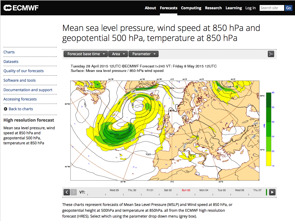
- numerical medium-range forecast charts, the only ones that are free,
- derived wind forecasts,
- lightning strikes worldwide,
- observation; there is nothing to beat correlation between what is happening in the sky and on the ground beneath with rainfall radar and satellite data.
It is worth taking the time to understand how to use rainfall radar and satellite data from the UK Met Office and the above resources to produce your own local forecasts – my third option.
Conclusion
Each of these apps is good, but constrained by the underlying data and our limited ability to forecast the weather.
Whichever you decide to use, remember that they will still be wrong quite often, usually when the weather is being least predictable.
In other words, the only thing that you can be certain about is uncertainty, and the need to take a mac, whatever is forecast.
